 If you have upgraded to Leopard OS on your Mac, you need Google Earth version 4.2. Earlier versions of Google Earth do not work on Leopard.
Download the latest version of Google Earth.
If you have upgraded to Leopard OS on your Mac, you need Google Earth version 4.2. Earlier versions of Google Earth do not work on Leopard. Google Earth Outreach has released a new set of tutorials for Google Earth and Maps.
 If you haven't already, be sure to check out the geotagging feature of Picasa. It allows you to tag photos you have imported into Picasa with a specific location using Google Earth. When you upload your photos to Picasa Web Albums, visitors who view your photos online can see where the images were taken in a Google Maps thumbnail. You can also share geotagged photos with others as a KML file or simply save the information in your own private album.
 I try not to break news on this blog. I leave that to Frank Taylor, Stefan Geens, and other bloggers. But you may not have noticed that in Version 4.2, there is a new button entitled Add Content at the top of the Places panel.
 Have you visited the Google 3D Warehouse lately? It now showcases Featured Google Earth Modelers. This area includes "photo-textured models of georeferenced (located in the right spot in Google Earth) buildings that are developed with efficiency in mind, creating the most beautiful result with the least amount of polygons as possible."
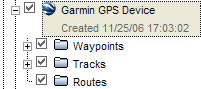 When you import GPS data into Google Earth, your tracks or waypoints may not initially appear. This is because the data includes time information and the time slider determines if such time-stamped data appears in the 3D viewer. Fortunately, there is an easy solution.