Occasional users of Google Earth may not be aware that content available in the Layers panel is frequently changed. Entirely new layers are often added and existing content is expanded and updated. It is a great idea to explore the Layers panel to see what is new.
As someone on the Google Earth team, even I have a tough time keeping up with it all. Lately, I find myself drawn to the following layers:
YouTube - (Gallery) Poke around in this layer and you can find some real gems. My favorites videos depict something that relates to a location. For example, near my hometown, someone posted a video of a driving tour of Christmas light displays around town. My kids loved this.
Weather - For the ultimate in dynamic content, enable this layer. Google recently began publishing weather for many additional locations. View current cloud cover, precipitation and forecasts. And don't forget to play with the clouds.
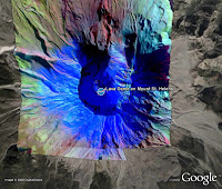
NASA Satellite Imagery - (Gallery > NASA) There is some fantastic alternate imagery of the planet available in this layer. Many of these images tell important stories about human and natural events around the globe, such as floods, dust storms, deep ocean whirlpools and more. Check out the photograph of Mount Saint Helens.
GigaPan - (Gallery) Again, this layer shows outstanding local imagery of fascinating locations. The imagery from Yellowstone National Park is a great example.
Friday, March 21, 2008
Tuesday, March 18, 2008
Pre-Hiking Reconnaissance
One of my favorite uses of Google Earth is to plan and scope out upcoming backcountry trips. Currently, I am plotting a overnight camping trip on the Pacific Crest Trail (PCT) near Mount Shasta in California. There are a number of ways to do this:
Navigate to the area - Tilt and check out the terrain. This will give you a sense of what you will find on your trip, including natural features, lakes, etc.
Display existing trails - (Layers panel > Gallery > Trimble Outdoors Trips) This layer has some excellent information about trails and the PCT in particular. It includes tracks, trailheads, distances, landmarks, pictures and more.
Import a map as an image overlay - I pulled in a USFS map for trails in the area, which included additional information about distances and landmarks.
Display names for natural features - (Layers Panel > Places of Interest > Geographic Features) These names are extremely helpful because they often correspond to topographical maps. Note that these names do not appear until you zoom in a bit.
Wednesday, March 12, 2008
Real Estate and Google Earth
Over the weekend, a friend and occasional user of Google Earth asked me about how he could use the software with his real estate business. There are many options, ranging from the simple to the elaborate:
Create placemarks of properties - Once you create and share placemarks, clients can virtually visit listings, read your descriptions, view videos and more.
Create polygons showing parcel boundaries - Again, this gives clients the opportunity to see exactly what it is you have to offer. Learn more.
Import your existing GIS data into Google Earth - Google Earth Pro can ingest your GIS data and allow you to publish much of this information to both Google Earth and Maps. As a large scale example, the City of Portland has published data for parcels, zoning, crime, school districts and more.
Create, import or place SketchUp 3D models - Using Google SketchUp, you can create or import simple or complex models of properties and place them in Google Earth. The 3D Warehouse has models ready for you to start with.
Monday, March 03, 2008
Extend to Ground
You can create lines that appear between a placemark and the ground. Of course, this line only appears if the placemark is elevated above the Earth.
To do this, first create a placemark. In the New Placemark dialog box, enter an altitude value above zero or use the slider and check Extend to ground.
Polygons, lines and paths can also extend to the ground. With these items, Google Earth draws a geometric shape from the earth's surface to the item.
Subscribe to:
Posts (Atom)