Time.com just posted a great list of top ten Google Earth finds. If it's got you hungry for more, the best place to find out about the weirdest, coolest things to see is always the Google Earth Community. I've been checking out the "Huge and Unique" forum, where users have posted hundreds of placemarks that you can download and view in Google Earth.
And it's easy too. If you're new to the community, look for attachments in the threads that interest you. Clicking on them will open a placemark, set of placemarks, or overlay right in Google Earth, and you'll see it in the Places panel. With finds like World's Biggest Sculpture and Faces in Google Earth, thanks to other users I'm well on my way to creating my own personal top ten.
Thursday, February 26, 2009
Monday, February 23, 2009
Think something's missing? Check your layers!
On the Google Earth Help Forum, we frequently get questions from users who aren't seeing something in Google Earth that they think they should be. Often, this problem has a simple cause: a particular layer is turned off.
Layers hold the key to most of the content you see in Google Earth and, since there are so many, its not always easy to remember which layers to toggle on or off to get the information that you want. Looking for the name of a street? Make sure you've turned on the Roads layer. Can't dive under the ocean? Chances are, it's because your Terrain layer is turned off. Sometimes, the layer you need isn't quite intuitive: If you're having trouble viewing the Titanic, it's probably because you need to turn on your 3D Buildings layer.
So, when it seems like there's something missing, the Layers menu can hold the solution. And while you're at it, why not check out a layer that you haven't seen yet? The wealth of information that's available might surprise you.
Thursday, February 19, 2009
Navigating Underwater in Google Earth
With the new Ocean layer, there's now so much more of the Earth to explore. But navigating underwater, and dipping above and below the ocean's surface, can take a bit of getting used to.
Diving underwater from the regular "top-down" view might seem a little disorienting. It's best to tilt your view first, so your view is almost parallel to the ocean's surface. This will give you the clearest view of the ocean floor terrain once you're underwater, and give you a better sense of how deep you're going .
There are three ways to tilt your view in Google Earth:
Note that crosshairs will appear wherever you click your mouse, and your view will tilt from this point.
Once your view is almost parallel to the ocean, keep zooming in until you are below the surface (note that you don't want to be completely parallel to the ocean's surface, otherwise you'll just fly over it without ever going underneath). When you're under the surface, you can "swim" around the same way that you'd navigate if you weren't underwater. Be sure to tilt your view upward to check out the ocean's surface from below.
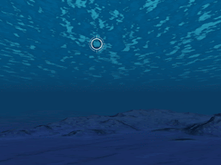
To come above water again, click anywhere on the ocean's surface, like in the image below. Tilting your view upward from that point will allow you to come up for air.

For more information about navigating in Google Earth, check out this section of the Google Earth User Guide.
Diving underwater from the regular "top-down" view might seem a little disorienting. It's best to tilt your view first, so your view is almost parallel to the ocean's surface. This will give you the clearest view of the ocean floor terrain once you're underwater, and give you a better sense of how deep you're going .
There are three ways to tilt your view in Google Earth:
- If your mouse has a middle button, hold it down and move the mouse forward or backward.
- If your mouse has a scroll wheel, press the shift key and scroll.
- Hold down the shift key and your left mouse button while moving your mouse.
Note that crosshairs will appear wherever you click your mouse, and your view will tilt from this point.
Once your view is almost parallel to the ocean, keep zooming in until you are below the surface (note that you don't want to be completely parallel to the ocean's surface, otherwise you'll just fly over it without ever going underneath). When you're under the surface, you can "swim" around the same way that you'd navigate if you weren't underwater. Be sure to tilt your view upward to check out the ocean's surface from below.
To come above water again, click anywhere on the ocean's surface, like in the image below. Tilting your view upward from that point will allow you to come up for air.

For more information about navigating in Google Earth, check out this section of the Google Earth User Guide.
Subscribe to:
Comments (Atom)