Thursday, November 16, 2006

Historical Map Overlays

Recently, Google released a set of Rumsey Historical Maps as a layer in Google Earth (see blog post). These are maps which appear over the Earth in the 3D viewer. They allow you to compare historical maps to the state-of-the-art geographical content that appears in Google Earth.

As cool as this is (and it is very cool), did you know that you can overlay any historical map you find using the overlay feature? For example, recently, I found an online image of a historical map of my hometown of Dedham, Massachusetts. I saved this image on my computer and then placed it as an overlay in Google Earth.

What I learned was fascinating. The playground in our neighborhood is all landfill; almost 100 years ago, it was part of the Charles River. Very few of the current streets in this neighborhood existed, but a few did. At the time, the entire neighborhood was called "Dedham Island", while this same neighborhood was always known to me as Riverdale.

You try this yourself by searching for an image of a map of your home town and placing it as an overlay in Google Earth. You can also contact the local historical society and see if they have any maps you could scan or obtain electronically. Of course, this makes a great school project for teachers and students.

To enable the Rumsey maps in Google Earth, in the Layers panel, open the Featured Content folder then the Rumsey Historical Maps folder. Choose the map you want to view or choose Map Finder to display icons for available maps around the world.

Learn more about using your own map overlays.

Wednesday, November 15, 2006

Using Different Controllers

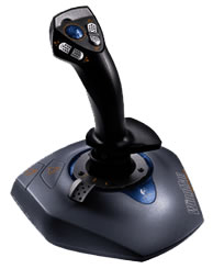
Using a mouse with a scroll wheel is an effective way to navigate in Google Earth , but it is only one way. Google Earth Version 4 also supports the use of different controllers such as joysticks. Navigating with these controllers can be more familiar to gamers, especially those who have used flight simulation products.

You can use GForce navigation setting in Google Earth to simulate joystick navigation when you are using a mouse. Using a joystick or other controller with the GForce setting, you can use the yoke to fly like an aircraft. To change to GForce mode, type Ctrl (Command/Open Apple Key on the Mac) + G when the window focus is in the 3D viewer. The cursor becomes an airplane symbol when you are in this mode.

Also note that keyboard shortcuts allow you to move using your keyboard. Learn more about navigation.

Friday, November 10, 2006

Hands On Learning

Today, we released a new set of Google Earth tutorials. These include the following subjects:

Navigating on the Earth
Searching for Locations and Businesses
Marking Locations

While these tutorials describe Google Earth basics, future tutorials will describe how to use more advanced features. I would love to hear from you about other topics you would like to see.

You always can access the latest tutorials within Google Earth ( click Help > Tutorials).

Wednesday, November 08, 2006

Terrain Options

You can change how Google Earth Version 4 displays the terrain (physical layout) of the areas you visit. There are two relevant options:

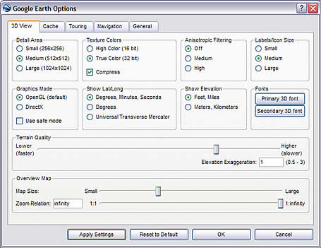
Terrain Quality - This setting allows you to determine how coarse or fine the Earth's terrain appears in Google Earth. To access these settings, click Tools > Options > 3D viewer tab (on the Mac, click Google Earth > Preferences > 3D View tab). Under Terrain Quality, use the slider to choose the appropriate level of detail. Using a Lower (faster) settings improves performance of Google Earth, but terrain appears less detailed. Using a Higher (slower) setting improves the depiction of terrain, but at the cost of performance.

Elevation Exaggeration - In this same dialog box (see above), change the Elevation Exaggeration value to depress or exaggerate terrain as it appears in the 3D viewer.

Learn more about these and other related options.

Tuesday, November 07, 2006

3D Buildings in Google Earth

You can view 3D buildings for many areas in Google Earth. There are a number of ways to do this.

3D Warehouse link
- Download this in Google Earth. This is a network link to Google's 3D warehouse. It allows you to view photo-realistic 3D buildings in Google Earth that are available in the 3D Warehouse. Once you have downloaded this, any geographically-referenced 3D model in the Warehouse appears in Google Earth as a special placemark that allows you to open the associated 3D building. Once you have downloaded the 3D Warehouse link, be sure that this link is checked in the Places panel. Learn more about this feature.

3D Building layer
- In the Layers panel, check 3D Buildings. This displays 3D buildings in various metropolitan areas. Learn more about using layers.

Create your own 3D model
- You can create a model of any building you like and place it Google Earth using Google SketchUp. Learn more about placing 3D models in Google Earth.

Thursday, November 02, 2006

New Version of Google Earth

Yesterday, Google released an updated Beta version of Google Earth 4. This release includes a number of neat, new features and enhancements, including:

Paths and polygons are included in Free - Users of the Free version can now draw both paths and polygons. Learn how to use these features here.

New icons - In addition to being more attractive, the pin of placemark icons point to the exact placemark location. There is also a new set of icons.

Image overlays can have altitude -This is useful for overlays such as weather radar images where you want to see the image from directly above, but also want to be able to see the ground imagery from an angle.

Printing - You can print search results and folders of placemarks.

Additional Pro features - A number of formerly premium features are now included in Pro, including premium printing quality, GIS data importing and movie making!

Increased performance of 3D models - These models (such as those created in SketchUp or imported from the 3D warehouse) now load quicker and appear more realistic.

Coincident placemarks expand - When a number of icons appear together in the 3D viewer and you click on them, they expand into a star-formation (see image on left). This de-clutters the view and allows you to chose which one you want to explore further.

This is a partial list of new features. Learn more. Or better yet, download the new version.

Wednesday, November 01, 2006

Voting on Earth

If you are in the United States, you probably know all about next week's elections. Google Earth can help you participate in this democratic process in a number of ways:

Learn where the elections are
- Google Earth offers a layer (2006 Election Guide) that shows you complete election information for races in congressional districts around the United States. This layer also shows the geographical border of each district. Read more here.

Register
yourself - Using the aforementioned layer, you can even register to vote! See the link at the top of each placemark balloon.

Understand the candidates
- Each placemark in this election guide layer includes links to news, images and other websites about the candidates.
To learn more about using layers, see the user guide or check out this earlier blog post.