Wednesday, November 19, 2008

Geotagging iPhone Photos

With the debut of of iPhone 2.0 software, you can enable the Camera app to geotag your photos on the iPhone 3G. To enable this on your iPhone, click the Settings icon > General > Location Services.

Once you've done this, all photos you take on the iPhone are assigned a location. You can then upload these photos to Picasa and then port them over to Google Earth using the geotagging feature of Picasa.

This saves you the step of manually geotagging your pictures. Plus, your family will be hugely impressed when you show them photo albums in Google Earth :-)

Looking at the Source

At anytime, you can view the KML source of items in the Places panel. To do this, select the item and click Edit > Copy. In a text editor, click Edit > Paste. The KML source appears in the new document.

Personally, I use this method to examine the source of Places data I've come across that show content in an interesting way. You can also examine the source of Layers content by right clicking (CTRL + click on the Mac) a point of interest in the 3D viewer, saving it to My Places and then use the method described above.

Thursday, October 30, 2008

Timeline Tutorial

Richard Treves is the author of kokae.com and blogs about the usability of Google Earth projects at Google Earth Design.

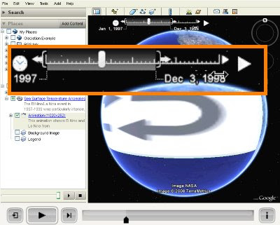
Recently, he created a very interesting timeline tutorial video that describes how to use the time slider in Google Earth. This particular post also provides a reasonable critique of this feature.

The time slider displays content in Google Earth along a sequence of time. Check out Frank Taylor's examples of time animations on gearthblog.com.

Learn more about using the time slider.

Friday, October 24, 2008

Creating Dynamic Views in Movie Maker

If you're making a movie in Google Earth, you might want to change the camera angle or altitude to change as you fly over different places. The best way to do this is to use placemarks, rather than a single path.

If you choose to have your movie follow a path, your camera angle and altitude will remain the constant along that path. When you create a placemark, you can create specific 'View' settings that affect the way it will appear in your movie. Mouse over each field in the 'View' tab for explanations of each term, or click Snapshot current view to apply your current view settings to that placemark.

In this way, you can make a more compelling movie that shows dynamic views.

Learn more about making movies.

Wednesday, October 22, 2008

KML Interactive Sampler

I am very excited by the recently-published KML Interactive Sampler (read the announcement). Using the Google Earth plugin, it allows you to test sample KML and see this content immediately in Google Earth. You can also play with your own KML. For example, you can copy and paste KML into the main field, click Update Earth and instantly see how your code will appear to end users.

For now, you'll need Windows to use this tool, as the Google Earth plugin is currently only supported on this platform. Rest assured that a soon-to-be-released Mac version is in the works.

Learn more about using KML.

Friday, October 17, 2008

Navigating and Embedding Photos

As Google has recently published new imagery in Street View, knowing how to navigate photos becomes even more useful. You can navigate high resolution imagery in the following layers:

Street View
Gallery > GigaPxl Photos
Gallery > GigaPan

To view this imagery, enable any of these layers and navigate to the appropriate location. Click an icon to enter the photo. Remember that you can move around within each photo by clicking or dragging the image. Learn more about navigating photos.


View Larger Map
spacer
You can embed your own custom Street View on your website using Google Maps. This is both easy and very cool (see example at left).

To do this, go to Google Maps and navigate to your favorite Street View. Click Link to this page, copy the web address from the Paste HTML to embed in website field in your browser and paste it into the HTML code of your website. To resize and preview the map, click Customize and preview embedded map.

Thursday, October 02, 2008

Searching for Planets

This functionality was not available when Sky launched, but now you can search for planets in our own solar system. For example, if you search for Mars, Sky shows you the planet at its approximate location at the time shown.

To do this, in the Search panel, click Search the Sky, enter the appropriate planet name and click the Search button.

Learn more about using Sky in the Google Earth user guide.