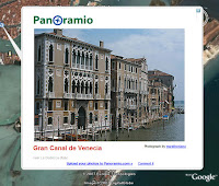
 I just can't help myself. I am having too much fun playing virtual tourist with the Panoramio layer in Google Earth. If you are not familiar with this feature, be sure to check it out.
Simply navigate to a favorite destination (say Venice, Italy). In the Layers panel, check Geographic Web > Panoramio. Just start clicking the icons in the 3D viewer:
The location of each icon represents where the photo was taken. I've used this layer to scope out potential summer vacation destinations with my family. Since I've begun to use it, I've noticed that the number of photos in this layer have grown tremendously, so it is worth it to check this layer frequently.
5 comments:
I'd love to be able to help you play tourist by adding some of my own images. I may well not be seeing the obvious, but I honestly cannot work out how to add my images - can you point me in the right direction for an idiot's guide please?
This document describes how to put your Panoramio images in Google Earth:
http://tinyurl.com/2yf7u3
How does one temporarily remove the photo icons?
While they are quite a nice feature, if your aim is to fnd a place, the icons can get in the way!
I use Google earth a great deal to find places I have to go to - in the UK, the postal code is a sure-fire way of finding a destination.
Also, why do some of the photos not load up when you click on them?
Hi Patsy. You can hide these icons by just unchecking the Geographic Web layer in the Layers panel.
The photos are retrieved from the Panaramio service. If there is a slow or unreliable connection, it can take a while for them to appear.
I've noticed that Panaramio is cool, but damn slow. Who owns Panaramio anyway? Why don't they buy some more servers?
Post a Comment