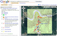
 I spend a significant portion of my free time as a volunteer planning and building trails. I've found Google Earth and Maps to be terrific tools for sharing information about such projects. Example: for years, I have worked with the BLM and local volunteer groups to create a new trail near the South Yuba River in Northern California. Using a GPS device, image overlays of topo maps and a lot of scouting in the field, I was able to create a visual depiction of our planned trail. You can see the preliminary route here:
Google Earth:
http://www.bonc.org/KML
Same data in Google Maps:
http://tinyurl.com/2hntw3
2 comments:
Where did you get the topo map image? I see you have imported it as a transparent image overlay. This would be very helpful for me in determining road grades for bike rides.
Hi Christopher. If I remember correctly, I scanned a USGS map to produce the image. However, you can obtain electronic versions of topo maps around the Internet.
This site creates electronic topo maps as KML overlays:
http://www.gpsvisualizer.com/kml_overlay
Post a Comment