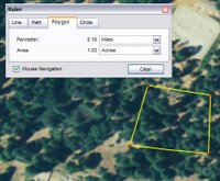
 Google Earth allows you to measure distances and areas on the Earth. What exactly you can measure depends on what version of Google Earth you have (learn more here).
The ruler feature represents a great way to quickly determine distances from Point A to Point B. To do this, simply click the ruler icon and click two points in the 3D viewer. Viola... the distance appears in the Ruler dialog box. You can do this via a line with multiple segments (a path) by clicking the Path tab in the Ruler dialog box and clicking multiple points in the 3D viewer.
Of course, all of this is different than measuring driving distances, which you can also do in Google Earth.
I am particularly impressed with the polygon and circle feature (Google Earth Pro only). It allows you to draw these shapes and determine figures such as perimeter and area. I used this recently when trying convince city planners in my home town to build a facility (a dirt bicycle jump area) in a public park. The planners wanted to know how we could fit such a one acre facility in the park. I pulled out Google Earth Pro and easily marked out an available park area that equaled a tad over one acre.
7 comments:
Yes, I love the function (I often measure airport runways)...
Question: how can the default (Miles) be changed to e.g. Meters?
I didn't find any entry in preferences.
For changing the units of measurement, just choose an appropriate selection in Ruler dialog box. In other words, where is says Miles, click and choose Meters.
Hope this helps.
soy sebaastian tengo 13 años y me gustaria me gorar la vista de la ciudad de cali colombia por eso solicito una forma de como ayudar a que la ciudad tenga mejor vista mi correo es sebas932@hotmail.com
John, I'm also having that annoying problem of the Ruler always starting in Miles.
Your instructions doesn't solve the problem.
It sounds as if you don't understand the question?
Is there any way of displaying speed when cruising over a terrain?
In response to Ferdi's question:
I think John perfectly understood the question posed... except for one problem. The first comment said "...the default (miles)...", which was misunderstood. What could have been said is "How can the default measurement be changed, as a new default, not on a measurement-by-measurement basis?"
The visible points created by measuring do not appear after using Google Earth for a short time. Neither do the lines showing the measurement line or path. The measurement can still be accomplished, but nothing is visible on the screen other than in the read-out box. When this occurs, starting a measurement becomes a problem, since just clicking a point doesn’t always start the measurement, and you must double click to start, although this doesn't always work either.
Post a Comment