 There are three main ways you can import imagery into Google Earth:
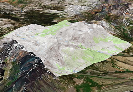
Image overlay - (Add > Image Overlay) This is an image that is draped over the surface of the earth (though it can appear elevated as well). Among other things, this feature is useful for importing image files of maps. The picture to the left is an example of an image overlay.
Photo - (Add > Photo) This is an image placed in a geographic location that you and other users can fly into and navigate. You can see examples in the Layers panel > Gallery > Gigapxl.
GIS imagery - (Google Earth Pro only: File > Open) These are GIS-related files, such as .tif, .geotif, .ntf, .img, etc. Google Earth can display these images in the correct geographic location as specified in the original file.
The larger your image files, the more performance becomes an issue. If you are using large sets of images, consider using KML Regions.
4 comments:
According to the Google Earth User Guide page, you can only import GIS data like imagery using Google Earth Plus, Pro or EC; the free version doesn't support it.
Re-reading the instructions, it's not clear that even Google Earth Plus supports importing georeferenced imagery - that may only be available in Google Earth Pro and higher.
You can use some kml network link to overlay some georeferenced aerial imagery, even with the free version of Google Earth.
See the example of the orthophoto of the city of Brest (France) hosted in the GeoGarage spatial image web server compatible with Google Maps and Google Earth.
http://kml.geogarage.com/brest/brest.kml
(1.6 Gb in ECW format / 11.25 gigapixels (125000x90000)
Thanks Leszek. I see that the user guide is not exactly clear in this regard. I'll make the appropriate edits soon. I've edited the blog post as well.
Post a Comment