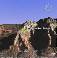
 The Snapshot View command allows you to assign a specific camera angle and altitude to a placemark or folder. For example, if I want to create a placemark of a mountain to share with others, but want to ensure that users see the mountain at specific angle to emphasize its topography, I would tilt and navigate until I get an ideal view and then use the snapshot view command. Anyone who views my placemark will see the precise view I set.
This can be a powerful feature if you area creating tours or movies in Google Earth, as a tour of a set of placemarks can use the precise camera angles that you want.
To snapshot a view, do one of the following:
- For a folder or placemark, right click (CTRL click on the Mac) the placemark and choose Snapshot View
- In the Edit Folder/Placemark dialog box, choose View > Snapshot current view
2 comments:
Hi
I am studying MSc Information Management in the University of Sheffield.
As part of my dissertation, I need to carry out a questionnaire.
My supervisor is Peter Willett (p.willett@sheffield.ac.uk). I would be very
grateful if you could follow the link below and complete my questionnaire about your use of Google Earth/Map.
If you have used Google Earth or Map, please help me to fill out my questionnaire which only takes you 5-10 minutes.
To participate please follow the link:
http://www.surveymonkey.com/s.aspx?sm=KVG_2fgKXcq_2faq72CQs4Qimg_3d_3d
Please accept my apologies if this post is not of interest to you.
All questionnaire responses will be collected anonymously.
I am a first time user interested in quality of terrain photos for hiking. Thanks
Post a Comment