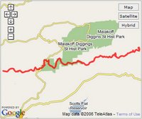
 I am an avid mountain biker and spent a considerable portion of the Thanksgiving break riding local trails. My fellow Googler and cyclist Dave joined me and brought his nifty Garmin GPSMAP 60CSx GPS device with him to track our trail riding.
Google Earth Pro and Plus allow you to import GPS data and display it in the 3D viewer. As someone who has used electronic maps for many years, I love this feature. You can see exactly where you rode and with terrain turned on, you can gain new perspective on your trek. Often, I view the GPS track of a ride and think "ahhhh... so that is why my legs hurt so much. That hill is steep!"
Other website designers have come up with innovative ways to display GPS data in Google Earth and Google Maps. One such site is mtbguru.com which makes very effective use of GPS and KML. It even displays geo-referenced photographs taken on the trails. MotionBased is another great web-based service that allows you to review GPS data and view it in Google Earth and Maps.
9 comments:
I don't quite get why people say that GPS support is only available using Plus and Pro. Some functions work for me with the free version. All I do is drop a GPX file into GE and Ta-Da.
Any explanation?
Hi Terry. Allow me to clarify. If you want to download GPS data directly from your GPS device into Google Earth via a USB or serial cable, you need the Pro or Plus version. But you are correct that you can open .gpx files in the free version.
Another site dedicated to serving GPS tracks of mt bike trails is:
http://www.crankfire.com/
It is a Connecticut-based group, but they support users adding trails in any state.
No need to spend money on PRO version to upload GPS tracks. Use http://www.gpsvisualizer.com/ convert to KMZ files. Way coo.
I use MacGPS Pro to convert my waypoints and tracks to .kml/.kmz files.
I've had great success using the free version of GE,, with gsp2geX with my Polstar BT100(?) bluetooth GPS receiver. Apple PowerBook 1.5 GHz, Mac OSX 10.4.8. Plots and tracks in real time, marks waypoints at 5 minute (or whatever) intervals. gps2geX is from this site http://www.grandhighwizard.net/.
Our developement is not on Google Driving Directions. We live in K. Hovanian, Four Seasons, Macungie, PA, 18062.
When will we be listed so friend can get directions to our home on the Google?
7089 Queenscourt Lane
Macungie, PA 18062
Another really good one for PPC WM5 is SurveyArea3. (see www.wildsoft.org). What distinguishes SurveyArea3 one from the rest is that it has Outlook integration which allows you to instantly send the kml file to any email address with the press of a button. It literally takes seconds from measuring a location with a GPS, to sending the kml as an email attachment anywhere in the world. No more hassles getting the file from your PPC to any desktop computer.
Works great with any wireless internet access, for example GPRS or Wifi etc.
you can also use free software such as gps trackmaker into the free version of GE, to see your tracks and geocaches, you can also create routes in GE save them as KML files and open them up in trackmaker the download them into your GPSr...
Post a Comment