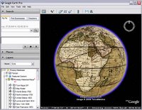
 Recently, Google released a set of Rumsey Historical Maps as a layer in Google Earth (see blog post). These are maps which appear over the Earth in the 3D viewer. They allow you to compare historical maps to the state-of-the-art geographical content that appears in Google Earth.
As cool as this is (and it is very cool), did you know that you can overlay any historical map you find using the overlay feature? For example, recently, I found an online image of a historical map of my hometown of Dedham, Massachusetts. I saved this image on my computer and then placed it as an overlay in Google Earth.
What I learned was fascinating. The playground in our neighborhood is all landfill; almost 100 years ago, it was part of the Charles River. Very few of the current streets in this neighborhood existed, but a few did. At the time, the entire neighborhood was called "Dedham Island", while this same neighborhood was always known to me as Riverdale.
You try this yourself by searching for an image of a map of your home town and placing it as an overlay in Google Earth. You can also contact the local historical society and see if they have any maps you could scan or obtain electronically. Of course, this makes a great school project for teachers and students.
To enable the Rumsey maps in Google Earth, in the Layers panel, open the Featured Content folder then the Rumsey Historical Maps folder. Choose the map you want to view or choose Map Finder to display icons for available maps around the world.
Learn more about using your own map overlays.
4 comments:
Impossible to see the historical maps...
I'm a mac user. I downloaded the last GoogleEarth (4.0.2413) and I use the french version.
I read somewhere* that you have to switch to the english version to see those maps, but on the mac there is no LanguageSettings on the preferences panel...
Any help ?
* http://www.gearthblog.com/blog/archives/2006/11/four_new_featured_go.html
Good question. Right now, these maps are only available to users of the English language version of Google Earth.
Google Earth automatically switches to the language used by your operating system after you restart the program.
Ah. Strange. I don't see the link between Historical maps and Language. I can read english maps. Annoying.
Note that these historical maps are now available to users of other languages:
http://www.gearthblog.com/blog/archives/2006/12/rumsey_historical_ma.html
Post a Comment