Yesterday, Google released an updated Beta version of Google Earth 4. This release includes a number of neat, new features and enhancements, including:
Paths and polygons are included in Free - Users of the Free version can now draw both paths and polygons. Learn how to use these features here.
 New icons - In addition to being more attractive, the pin of placemark icons point to the exact placemark location. There is also a new set of icons.
Image overlays can have altitude -This is useful for overlays such as weather radar images where you want to see the image from directly above, but also want to be able to see the ground imagery from an angle.
Printing - You can print search results and folders of placemarks.
Additional Pro features - A number of formerly premium features are now included in Pro, including premium printing quality, GIS data importing and movie making!
Increased performance of 3D models - These models (such as those created in SketchUp or imported from the 3D warehouse) now load quicker and appear more realistic.
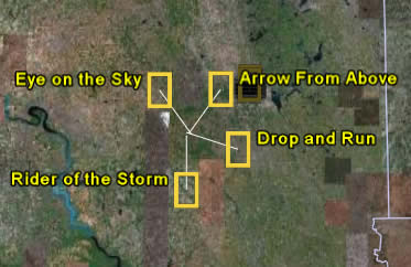 Coincident placemarks expand - When a number of icons appear together in the 3D viewer and you click on them, they expand into a star-formation (see image on left). This de-clutters the view and allows you to chose which one you want to explore further.
This is a partial list of new features. Learn more. Or better yet, download the new version.
3 comments:
Thank you for all the work you are doing with this great projects. I wish you great success. I wonder when you will have the State of Wisconsin in your 3d status. I would be glad to contribute extra shekels for the improvement. On a recent update, you missed my village, CLINTON by about 20 miles. Again, best wishes from tom Vogt
Wow, God like. I'm floored by GE4.
I use it to have my flight students "fly" their proposed flights. I can "fly" over impressive terrain or from airport to airport. It would be cool to have an option in the Pro edition perhaps for a joystick to fly over terrain or water. Thank you all. Nice work.
Tom Perez
Certified Flight Instructor
Using an info tool to get the length of existing paths, and to get the area of a polygon would be great. Also, I see in the "Fire maps example" a spreadsheet graphic. Would I assume correctly that Google earth#4 plots points from a spread sheet with lat lon columns?
Post a Comment