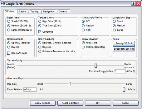
 You can change how Google Earth Version 4 displays the terrain (physical layout) of the areas you visit. There are two relevant options:
Terrain Quality - This setting allows you to determine how coarse or fine the Earth's terrain appears in Google Earth. To access these settings, click Tools > Options > 3D viewer tab (on the Mac, click Google Earth > Preferences > 3D View tab). Under Terrain Quality, use the slider to choose the appropriate level of detail. Using a Lower (faster) settings improves performance of Google Earth, but terrain appears less detailed. Using a Higher (slower) setting improves the depiction of terrain, but at the cost of performance.
Elevation Exaggeration - In this same dialog box (see above), change the Elevation Exaggeration value to depress or exaggerate terrain as it appears in the 3D viewer.
Learn more about these and other related options.
1 comment:
The new higher-resolution images covering Edinburgh are welcome. However, the terrain data (at least in one area of particularl interest to me) is worse than before! At position
lat 55.945125
lon -3186725
Google Earth shows a height of 91m.
The true height at this location is around 82m. (We are constructing a new building on the carpark seen immediately to the W of this location, so have detailed and accurate height data available.) Other nearby heights are also wrong, but the error varies, so the local topography is rendered wrongly (as well as the absolute height being incorrect). This makes it impossible to place3d models on the terrain.
With the previous low-res images the terrain data for this area was more accurate.
Post a Comment